NASA PHOTO FROM THE SPACE
SHUTTLE MISSION PROGRAM
WAS MT. SINAI A VOLCANO? DISCOVERIES AFFECTING THE INTERPRETATION OF EXODUS |
|
Introduction | Early
Exploration | Geology | Parting
Remarks |
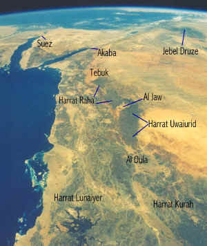
NASA PHOTO FROM THE SPACE
SHUTTLE MISSION PROGRAM
The volcanic mountains of north-west Arabia are about 125
miles southeast of Akaba/Aquaba,
Jordan. The 140 mile long chain of sandstone, basalt, and volcanoes begins
above the town of Tebuk in the north and terminates above the town of Al Oula in
the south. During my years of research. I collected some of the writings of others
who described this area. In December of 1847 Dr. George Wallin of Finland left Suez, Egypt and traveled
until he reached Arabian coast near Sharmah. He hired a small clan of Bedouin and some
camels to carry his gear through the mountains eastward to Tebuk. On his way south
from Tebuk towards the oasis of Taima he noted in his journal that he found a rock like a cinder that was porous and
very light. This pumice rock was a product of a volcanic eruption in the
225 km. long volcanic mountain range named Harrat Uwaiurid and Harrat Raha. (Notes
Taken During A Journey Through Part Of Northern Arabia in 1848 by Dr. George Wallin of Finland)
Dr. Charles Beke reported a theory about the volcanic nature of Mt.
Sinai. In January of 1874, Dr Beke of England boarded the
steamship Erin from Suez, Egypt for a ten day cruise to Akaba, Jordan a port on the Gulf
of Aquaba on the Red Sea. He investigated a rumor that Mt. Baghir was the
historic Mt. Sinai in the Wadi Ithym above Akaba. He witnessed a spectacular
thunderstorm on the mountain but found no volcanoes. (Gold Mines of Midian, by R.
Burton, 1878).
Charles Doughty of England reached the Harrat Uwaiurid in 1877. Doughty had witnessed an
eruption of Vesuvius in Italy some time before he found an area on the high lava
platform. He spent two years in Arabia at great risk to his own life as he was not
Moslem. These words were recorded by Doughty:
"We ascended northeastward upon an ancient
lava-stream, such a one as those vast floods which I had seen issue forth from Vesuvius a
few years before. The molten stone had seyled
down the Arabian valley of sandstone, when the Aueyrid was nearly as we see at present. When we were come upon the main lava-field above,
it seemed like nothing so much as an immeasurable cow shard: a startled troop of gazelles scudded before us;
here they are robust, and nearly of the colour of basalt; - gazelles are white in the sand
plains. After the lava crusts we rode upon black sand, and upwards under a crater hill; and beyond I saw a
wonderful new and horrid world of volcanic rusty hills and craters,--black powder, sharp lava slag, and
cinders, was this soil under our camels feet. The
volcanelli appeared standing so thick that bye and bye looking about us I counted above
thirty at once."
Doughty
also reported a cinder cone in a different scene. He was not one to greatly
exaggerate:
" ... I came to a cone and crater of the smallest here seen 300
feet in height, of erupted matter, pumice and light rusty cinders, with many sharp ledges
of lavas. The hill side was guttered away … by the few yearly showers in long
ages." (Travels in Desert Arabia, by Charles M. Doughty, 1888 London)
A Czechoslovakian named Alois Musil visited this area in 1910. He visited
the basin marked Al Jaw on the map image at the bottom of this page and reported:
"At 12:36 the volcano of al Bedr presented a fine
view, rising as it does above the gray table mountain of Tadra, which stands in the midst
of the fertile, pale green basin of al-Gaw. Behind
it, far away to the west, rise red and white slopes." (7/2/1910 journal
entry published in The Northern Hijaz pg. 216).
"Tadra and the entire
surrounding district is associated with various legends. The volcano of al Bedr is said once
to have vomited fire and stones, destroying many Bedouins and their camels and sheep." (The Northern Hijaz,
Alois Musil 1926)
The flat topped mountain Tadra is a sandstone mesa.
Al Bedr is a volcano on Tadra. A Saudi/USGS map indicates Tadra is 1500 meters
above sea level. Satellite evidence indicates recent volcanic activity in this
area. Remote sensing of western Arabian volcanoes recorded in writings as being active in the
past two millennia are similar in appearance to the photos I acquired. A
satellite photo of Tadra is shown on another page of this site.
The
described volcanic areas were closest to Israel of the Arabian volcano
fields. There were other areas that exhibited recent volcanic activity
into historic times.
More recent discovery of these volcanic areas might be viewed
on the next page titled: Geology